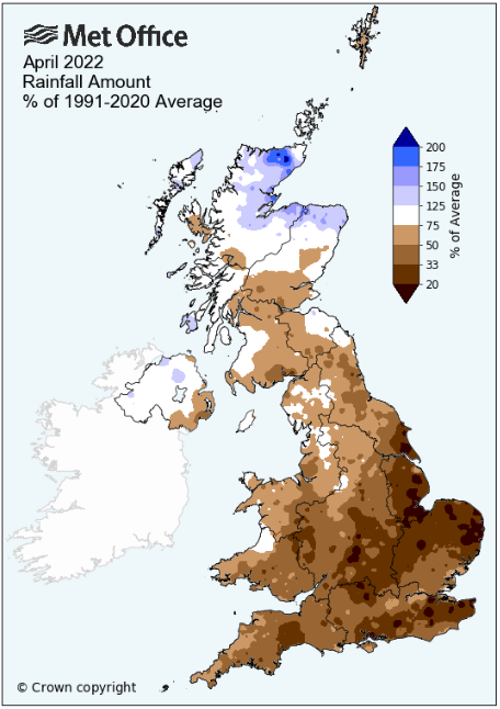
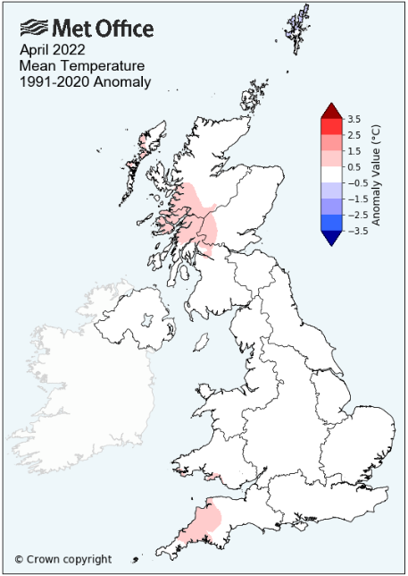
Dry - average for temperature
Unlike the April's of the last two years, April 2022 was much more ordinary and gave very little to talk about - drier than average, especially dry in the second half and with the temperature finishing bang on average.
The month began on a cool note through to the 10th with some frosts and was also unsettled during the 3rd-10th in which time most of the month's rain had fallen. Pressure then built and the weather became more settled, dry and milder and many days enjoyed some fine, spring-like weather.
The month would then finish much cooler with a return of overnight frosts.
High pressure (HP) to the west of Eire that extended south from Iceland controlled the weather during the 1st to the 4th, bringing a cold N'ly flow. The first three days saw slight frosts, sunny spells and the occasional light hail shower. Day-time temperatures were also below par, just over 8°c 1st/2nd.
During the 3rd low pressure (LP) to the east of Iceland started to squeeze the HP out with an associated front moving across the UK overnight into the 4th which brought 5.8 mm of rain (3rd). LP would then drive the weather through to the 8th, bringing some rain every day, 8.3 mm on the 6th the most, and whilst night-time minima was now above average, day-time temperatures recovered slightly into double figures, but remained below average. Come the 7th the LP system that had brought the previous days rain had moved into the Baltic which resulted in a cold N'ly flow been introduced down its western flank. Subsequently the 7th was a cold day with a stiff NW'ly breeze and only attained a maximum of 6.8°c. Pressure fell to 970.8 MB on the 7th which is a new April low at this site.
In that NW'ly flow the 8th opened with a sharpish frost of -3.3°c and during the day the pressure gradient slackened slightly as HP built in the Atlantic. The HP migrated into Biscay but ridged over the UK and the weather settled to overnight frosts and reasonably sunny, although cooler days; hail fell on both the 8+9th. Those frosts on each of the 8-10th achieved parity, -3.3°c being recorded on all three nights.
The HP moved further east into Europe and just about held the LP in the Atlantic at bay, but on the 12th a LP system developed over south Wales, moving north, giving a wet and murky afternoon and evening (7.9 mm). Behind this, HP once again ridged north from Biscay, the centre then moving north into France and then becoming part of a HP now over Norway. This would be in time for the Easter weekend (15-18th) and consequently the weather became dry and settled. It wasn't always sunny though, indeed a haze persisted on several mornings and 'cloudy but bright' was possibly more apt. LP in the Atlantic did make some headway late on the 17th and gave a brief spell of rain (2.7 mm) between 2300-0200h, although with a maximum temperature of 18.1°c this was the month's warmest day.
The Bank Holiday Monday (18th) would be much cooler (12.4°c) with those fronts from overnight ensuring another 'cloudy but bright' start. However, as the pressure gradient slackened, now the sun did burn that cloud away and the afternoon was more than decent with plenty of sun.
The 19-20th were transitional days with HP ridging down from Norway - with no rainfall recorded on the 20th that day of the year continued its record of being the driest day of the year. Only once in my 15yrs of records has it recorded any rain and that was just 0.5 mm in 2012.
From the 21st a new area of LP in the Atlantic was forced south into west Biscay by that HP, which now took up position in between Iceland and Norway. This had the effect of drawing in an E-NE'ly breeze which was quite stiff at times and which certainly had a coolness about it. However, it remained sunny and dry.
On the 25th the pressure gradient became slacker and that wind finally eased. Temperatures now dipped by both day and night and after a couple of cloudier days, HP became established over the UK from the 27th and the sun returned. All of the 27-29th started with frosts and the 28th was a cool day, failing to attain 10°c, but the 29th was simply lovely with sun all day long and which was pleasantly warm at 16.2°c.
The first meaningful rain for some time would arrive on the afternoon of the 30th, continuing overnight into the 1st, but which with 10.5 mm made the 30th the month's wettest day.
MSLP of 1016.8 Mb was +3.1 MB above the local average for the month and overall a mean minimum of 2.71°c and a mean maximum of 12.69°c saw the temperature 0.03°c below the thirteen year average for this site.
It was the warmest April since 2020 and since 2009 when the record began, eight have been warmer and five have been colder - the highest maximum temperature recorded during the month being 18.1°c (17th), the lowest minimum -3.3°c (8/9/10th).
Rainfall of 43.8 mm (Maulds Meaburn North 44.1 mm -- Castlehowe Scar 54.0 mm) was 86.6% of average for 2008-21, making it the wettest April since 2019. In a record that commenced in 2008, six have been drier and eight have been wetter.
During the month the following was recorded: hail fell on four days - the wind speed averaged 7.13 mph, with a maximum gust of 46 mph (6th).
We had 10 Air Frosts in the month (year 32) -- Grass Frosts totalled 16 (year 78).
The 1 foot soil temp ranged from a low of 6.7°c on the 10th to a high of 10.9°c on the 18th -- with a monthly mean of 9.1°c
The 1 meter soil temp ranged from a low of 7.8°c on the 11-13th to a high of 9.6°c on the 30th -- with a monthly mean of 8.6°c
This makes the Jan' to April period of 2022 1.03°c warmer than the average for 2009-21 and with 80.6% of average rainfall for 2008-20
At the Met' Office site at Shap a mean minimum of 1.4°c and a mean maximum of 11.7°c saw the monthly mean temperature 0.2°c below average and made it the warmest April since 2020. In a record back to 1992 (one year missing), 17 have been warmer, 11 colder and one was the same.
Rainfall of 62.0 mm represents 66.4% of its average. It was the wettest April since 2018 and in a record that commenced in 1989, seven have been drier and 26 have been wetter.
At Appleby in Westmorland rainfall of 45.3 mm represents 95.6% of its average (1857-2021) and made it the wettest since 2019 - in a record that commenced in 1857, 79 have been drier and 86 have been wetter.
Across the majority of the county rainfall was below average and typically in the proximity of 70% of average, but as usual, with a few deviations. In a fairly narrow strip through the central east of the county a few locations had a fall that was very marginally above average. This saw Sebergham (118.6%) finishing as the wettest location when expressed as a percentage through to Kirkby Thore (103%) and on to Warcop (107.1%). However, slightly north of this strip the average was down to 68.5% at Haresceugh and just to the south at Appleby In Westmorland it was 95.6% falling even further to 51% by Aisgill Moor.
This was though was the exception - a few locations had totals in the range of 55-65% but out at Seaton (Workington) the average fall was down to 42%, but this stood a little on its own, but which was replicated on the other side of the Solway Firth.
Across the county most of the month's total fell in the first ten days during which the 5-6th saw some reasonably high totals (52.4 mm at Mickleden on the 5th which was Cumbria's highest 24Hr total) with the second half of the month being very dry.
Figures from the Environment Agency�s rainfall sites were, (figure in brackets being the monthly average for 1991-2020) �Data kindly provided by the Hydrometry and Telemetry team of the Environment Agency (Penrith)�:
Kirkby Thore 46.0 mm -- (44.6 mm)
Haresceugh Castle (Kirkoswald) 42.79 mm -- (62.5 mm)
Brothers Water 99.05 mm -- (141.3 mm)
Orton (Shallowford) 53.2 mm -- (77.8 mm [average for 1967-2021]) - making it the wettest since 2019 and since 1967 when the record commenced, 14 have been drier and 41 have been wetter.
Seathwaite Farm (Borrowdale) 149.0 mm -- (181.0 mm [average for 1845-2021]) - making it the wettest since 2018 and since 1845 when the record commenced, 73 have been drier and 104 have been wetter.
JANUARY 2010
FEBRUARY 2010
MARCH 2010
APRIL 2010
MAY 2010
JUNE 2010
JULY 2010
AUGUST 2010
SEPTEMBER 2010
OCTOBER 2010
NOVEMBER 2010
DECEMBER 2010
JANUARY 2011
FEBRUARY 2011
MARCH 2011
APRIL 2011
MAY 2011
JUNE 2011
JULY 2011
AUGUST 2011
SEPTEMBER 2011
OCTOBER 2011
NOVEMBER 2011
DECEMBER 2011
JANUARY 2012
FEBRUARY 2012
MARCH 2012
APRIL 2012
MAY 2012
JUNE 2012
JULY 2012
AUGUST 2012
SEPTEMBER 2012
OCTOBER 2012
NOVEMBER 2012
DECEMBER 2012
SUMMER 2012
REVIEW OF 2012
JANUARY 2013
FEBRUARY 2013
MARCH 2013
APRIL 2013
MAY 2013
JUNE 2013
JULY 2013
AUGUST 2013
SEPTEMBER 2013
OCTOBER 2013
NOVEMBER 2013
DECEMBER 2013
REVIEW OF 2013
JANUARY 2014
FEBRUARY 2014
MARCH 2014
APRIL 2014
MAY 2014
JUNE 2014
JULY 2014
AUGUST 2014
SEPTEMBER 2014
OCTOBER 2014
NOVEMBER 2014
DECEMBER 2014
WINTER 2014
REVIEW OF 2014
JANUARY 2015
FEBRUARY 2015
MARCH 2015
APRIL 2015
MAY 2015
JUNE 2015
JULY 2015
AUGUST 2015
SEPTEMBER 2015
OCTOBER 2015
NOVEMBER 2015
DECEMBER 2015
REVIEW OF 2015
JANUARY 2016
FEBRUARY 2016
MARCH 2016
APRIL 2016
MAY 2016
JUNE 2016
JULY 2016
AUGUST 2016
SEPTEMBER 2016
OCTOBER 2016
NOVEMBER 2016
DECEMBER 2016
REVIEW OF 2016
JANUARY 2017
FEBRUARY 2017
MARCH 2017
APRIL 2017
MAY 2017
JUNE 2017
JULY 2017
AUGUST 2017
SEPTEMBER 2017
OCTOBER 2017
NOVEMBER 2017
DECEMBER 2017
REVIEW OF 2017
JANUARY 2018
FEBRUARY 2018
MARCH 2018
APRIL 2018
MAY 2018
JUNE 2018
JULY 2018
AUGUST 2018
SEPTEMBER 2018
OCTOBER 2018
NOVEMBER 2018
DECEMBER 2018
REVIEW OF 2018
JANUARY 2019
FEBRUARY 2019
MARCH 2019
APRIL 2019
MAY 2019
JUNE 2019
JULY 2019
AUGUST 2019
SEPTEMBER 2019
OCTOBER 2019
NOVEMBER 2019
DECEMBER 2019
REVIEW OF 2019
JANUARY 2020
FEBRUARY 2020
MARCH 2020
APRIL 2020
MAY 2020
JUNE 2020
JULY 2020
AUGUST 2020
SEPTEMBER 2020
OCTOBER 2020
NOVEMBER 2020
DECEMBER 2020
REVIEW OF 2020
JANUARY 2021
FEBRUARY 2021
MARCH 2021
APRIL 2021
MAY 2021
JUNE 2021
JULY 2021
AUGUST 2021
SEPTEMBER 2021
OCTOBER 2021
NOVEMBER 2021
DECEMBER 2021
REVIEW OF 2021
JANUARY 2022
FEBRUARY 2022
MARCH 2022
OTHER ARTICLES
The Oldest Inhabitant
An Inch Of Scotch Mist
But it's meant to be Summer (Summer 2017)
© Darren Rogers 2010-22
Want to comment on this site? email